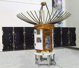
Faced with the prospect of increasing regional militarisation of space, given China’s on-going efforts to deploy constellations of both GPS navigation, defence communications and radar-imaging satellites at breakneck speeds, the Defence Research & development Organisation (DRDO) has authored a detailed and time-bound roadmap for the development and deployment of military satellites for both secure military communications and overhead reconnaissance for submission to the Indian Space Research Organisation (ISRO), India’s national agency responsible for developing space applications satellites and their launch vehicles. The first segment of the DRDO-authored roadmap will be realised later this year when ISRO launches the first dedicated military communications satellite for the Indian Navy. The multi-band satellite, weighing 2,330kg (5,137lb) and costing US$212 million, will be parked into a geostationary orbit 1,000nm above the Indian Ocean, and network the Navy’s principal surface combatants, submarines, aircraft, unmanned aerial vehicles and land-based operation centres through a secure high-speed data-link system, known as Link-2, which was jointly developed by the Navy and DRDO, and is being produced by Bharat Electronics Ltd. The footprint of the communications satellite will include the Strait of Hormuz and Horn of Africa in the west, the Indian Ocean Region, and the Malacca Straits and southern South China Sea to the east. This satellite will be joined next year by the Oceansat-3, which will be used by the Navy for bathymetric analysis which in turn is a prime prerequisite for conducting both undersea warfare and anti-submarine warfare. Oceansat-3 will be followed in 2014 by the $25 million communication-centric intelligence satellite (CCI-SAT), presently being developed by the DRDO’s Hyderabad-based Defence Electronics Research Laboratory. Weighing less than 1,000kg, it will be equipped with both communications transponders as well as a synthetic aperture radar (SAR) for gathering all-weather radar imagery for strategic targetting purposes. It will orbit the Earth at 500km. Proceeding in parallel are efforts to deploy the Indian Regional Navigational Satellite System (IRNSS)—a constellation of seven GPS navigation satellites (having on-board L-5 band and S-band transponders) in geo-stationary orbit over the Indian Ocean by 2015. Three satellites will be in geostationary orbit over the Indian Ocean.
Presently, India has a deployed constellation of ISRO-built earth observation satellites in sun-synchronous orbits that have dual civil-military applications. The first such satellite to be launched was the Technology Experiment Satellite or (TES), an experimental satellite to demonstrate and validate, in orbit, technologies that could be used in the future overhead reconnaissance satellites developed by ISRO. TES weighs 1,108kg and was successfully placed in 568km sun-synchronous orbit on October 22, 2001 using the PSLV-C3 version of the ISRO-developed polar satellite launch vehicle (PSLV). The technologies demonstrated in TES were attitude and orbit control systems, high-torque reaction wheels, new reaction-control system with optimised thrusters and a single propellant tank, lightweight spacecraft structure, solid-state recorder, X-band active phased-array antenna, improved satellite positioning system, miniaturised TTC and power system, and two-mirror-on-axis camera optics. The TES had a panchromatic (PAN) camera capable of producing images of 1-metre resolution. The Cartosat-1, weighing around 1,560kg at launch, is primarily used for cartographic purposes. It was launched by the PSLV-C6 rocket launcher on May 5, 2005. Cartosat-1 carries two PAN cameras that take black-and-white stereoscopic pictures of the earth. The swath covered by these high-resolution PAN cameras is 30km and their spatial resolution is 2.5 metres. The cameras are mounted on the satellite in such a way that near simultaneous imaging of the same area from two different angles is possible. This facilitates the generation of accurate three-dimensional maps. The cameras are steerable across the direction of the satellite’s movement to facilitate the imaging of an area more frequently. The images taken by Cartosat-1 cameras are compressed, encrypted, formatted and transmitted to the ground stations. The images are reconstructed from the data received at the ground stations. Cartosat-1 also carries a solid-state recorder with a capacity of 120GB to store the images taken by its cameras. The stored images can be transmitted when the satellite comes within the visibility zone of a ground station. Cartosat-2, weighing around 680kg, was launched by the PSLV on January 10, 2007. It carries a PAN camera that takes black-and-white photos of the earth. The swath covered by the camera is 9.6km and spatial resolution is less than 1 metre. The satellite can be steered up to 45 degrees along as well as across the track. Cartosat-2 is capable of providing scene-specific spot imagery. The data from the satellite is being used for detailed mapping and other cartographic applications at cadastral-level, as well as applications in land information system (LIS) and geographic information system (GIS). Cartosat-2 can produce images of up to 80cm in resolution. Cartosat-2A, which was launched by PSLV-C9 on April 28, 2008, carries a PAN camera capable of taking black-and-white pictures. The satellite can be steered up to 45 degrees along as well as across the direction of its movement to facilitate imagery collection of any area more frequently. Cartosat 2B, weighing 694kg, was launched on July 12, 2010. It too carries a PAN camera capable of taking black-and-white pictures. The Cartosat-3 is scheduled for launch later this year. Offering a swath width of 16km, it will be able to deliver take stereoscopic photos with a resolution of 25cm. It will use 1.2 metre optics with 60% of weight removal compared to Cartosat-2. Other features include the use of adaptive optics, acousto-optical devices, in-orbit focusing using MEMS and large-area lightweight mirrors.


Prasun, can you change the setting as comment section open in a new window.
ReplyDeleteWhen India going for 25 cm CARTOSAT-3 why we need to cooperate with Isarel for Optsat 3000 which has 50 cm resolution? Are you sure about this?
ReplyDeleteCARTOSAT-3 and Optsat 3000 will be meant for different user-agencies.
ReplyDelete