


Inference: Whenever two neighbouring
countries, when negotiating the delineation (on maps) and demarcation (on
ground) of the mutually-applicable international boundaries (IB), resort to
previous international treaties and historical paperwork relating to customary
laws and traditions, this is not the case with Mainland China and India
because, while the latter has documentation of the McMahon and Johnson-Ardagh
Lines, the former has no such corresponding historical treaties or maps in its
possession, since all such documentation was transferred from the Kuomintang
(Nationalist) government in 1949 from Nanking (Nanjing) to Taiwan, where they
today are preserved in a hardened underground tunnel complex located underneath
the National Chiang Kai-shek Memorial Hall at Taipei’s Zhongzheng District.
And without such documentation, China finds it impossible to agree on any legal
parameter that is required for delineating and demarcating any IB and hence
always insists that such documentation be superceded by a “political settlement”.
It is for this reason that Mainland China will NEVER agree to negotiate the
delineation and demarcation of not just the LAC, but even a legally-binding IB.
How Tibetan Ineptitude Reduced Pandit Nehru's Policy Options On Tibet


Inference: While popular perception
dictates that India’s first Prime Minister Pandit Jawaharlal Nehru needs
to be repeatedly excoriated for his government’s nonchalance in the face of
stealthy military incursions by Mainland China into eastern Ladakh throughout
the 1950s and 1960s, and for the disastrous and misguided “forward policy”,
which constituted the actual casus belli for the Sino-Indian border-conflict of
1962, little-known historical factoids instead prove that it was the sheer
ineptitude of the Tibetan government between 1949 and 1950 that forced Pandit
Nehru to compromise with Mainland China throughout the 1950s.
Tibetan Uprising Origins

The CIA Starts Helping


Raising Of Special Frontier Force

CIA Wants Out, KGB Wants In


CIA Stirs Unrest Inside TAR, While R & AW Manipulates Dharamsala


Galwan River-Valley Clash Explained


34 45 40.71 N, 78 13 6.79 E
The first signs of discomfort
in India started when the China a few days ago began pressing hard for another
round of Corps Commander-level meeting to kickstart talks on the Panggong Tso Lake
standoff. The PLA even moved a request for a Corps Commander-level meeting on
June 16. India, however, declined and had conveyed to China’s interlocutors
that a higher-level meeting would only be possible after complete disengagement
from the Galwan Valley. This decision was taken at the highest levels. The
issue on the table from an Indian standpoint were two semi-permanent structures
with tents on PP-14 (Patrolling Point) in Galwan. The PLA-BDR troops had moved
back some distance following local commander-level talks, but had refused to
remove these structures. At PP-17 in Gogra/Hot Springs, China had apparently
raised objection to some Indian Army hutments. In the recent past, PLA-BDR troops
have acted in a pattern where they move up, build tented structures and then
move back after talks without demolishing what they had made. This was flagged
off by the Indian Army as a way to make re-occupation easier at these heights.
However, pending resolution of these issues on Galwan, China was keen to start
conversation on the Finger Areas of Panggong Tso. At that stage, a high-level
meeting took place in Delhi on June 12 where it was decided that India will
insist on complete resolution of the dispute in Galwan before moving on to Panggong
Tso. South Block was, in fact, gearing up for a more protracted conversation on
getting the PLA-BDR troops to move back from Finger-4 in Panggong Tso. It was
felt that the PLA would be more belligerent there as it had moved into
advantageous ground.


It was the People’s Liberation
Army’s (PLA) insistence of constructing an observation post (OP) at Indian
patrolling point (PP) that resulted in the violent scrap between the two sides
on the evening of June 15. The post would have helped the PLA to not only
observe Indian troop movements towards the Karakoram mountain range, but also would have had the
capacity to interdict army vehicles plying on the Darbuk-Shyok-Daulet Beg Oldi
(DS-DBO) road. Most importantly, the OP was on India’s side of the Line of
Actual Control, or LAC. While India’s External Affairs Minister S Jaishankar red-flagged this issue in his
conversation with his Chinese counterpart Wang Yi, it is quite evident that the
PLA had a pre-meditated plan in the garb of de-escalation to change the agreed
alignment of the LAC and push out Indian Army from PP-14. This would have been
hugely detrimental to Indian interests. Set-up in 1978 by the Indian Army, PP-14
is on a ridge that overlooks both the Galwan River Valley and the Galwan Nullah,
which joins the Shyok River on whose bank the DSBO road is being build by
Indian Army and BRO engineers. The June 6 meeting between the military
commanders of China and India had even defined the number of
troops to be present at each point leading to PP-14. But even as the
de-escalation was on, the PLA wanted to put up an OP near PP-14 on grounds that
it wanted to observe the dis-engagement of troops. This was strongly objected
to by 16 Bihar Battalion’s Commanding Officer Col Santosh Babu, who rightly saw
this as the breach of laid-down rules of disengagement. Around dusk on Monday,
June 15, Col Santosh and his Company Commander went up to PP-14 and told his
PLA counterpart to pull down the OP. A heated exchange ensued, more troops
rushed in from both sides, and punches were thrown. The PLA, which has a base
camp down from the ridge near the Galwan River, rushed in more troops in
armoured personal carriers to the nearest road-head to PP-14. Initially, the
Indian Army troops were present in significant strength, but the PLA soon
outnumbered them. While China’s Foreign Minister Wang Yi has asked India to
punish its troops for breach of discipline, the fact is that the PLA wanted to
set up the OP as part of its efforts to redefine the LAC. PLA officers had told
Indian Army officers before the scrap that the alignment of the LAC was behind
PP-14. The illegal OP would not only have made the Indian position at PP-14
untenable, but also given a huge tactical advantage to the PLA with the option
of interdicting Indian Army movement on the soon-to-be-constructed bridge with field
artillery or direct-fire. If the OP had been allowed to be set-up the Indian Army
supplies to DBO camp ahead would have been at the mercy of the PLA. With more
than 600 troops involved in fisticuffs and hand-to-hand combat, the mountain ledge on which
the fighting was taking place gave away to a landslide. This led to casualties
on both sides as the troops fell into the Galwan Nullah and River, with a
section of Indian Army troops being isolated on the other bank of the
tributary. Drenched in the ice-cold water of Galwan River and with temperatures
running way below zero, the Indian Army troops had nowhere to hide against the
elements at an altitude of 16,000 feet ASL. A large number of Indian casualties
are on count on standing out in the open in wet clothes to prevent the PLA from
taking control of PP-14. The PLA engaged in a show of strength on the morning
of June 16 by bringing in more armoured personnel carriers to the nearest road
head to intimidate their Indian counterparts. The PLA had also linked the
dis-engagement on PP-15 (in Gogra/Hot Springs) to the Indian Army allowing the
OP being built near PP-14 on the Indian side. It was the courage of Col Santosh
and his men that prevented that.
 The clash between Indian Army and
PLA troops in which both sides suffered casualties on June 16 began at around 7pm
in the Galwan Valley when an Indian Army squad of about 50 soldiers, led by
Colonel Santosh Babu, reached a contested site near PP- 14. The soldiers were
unarmed, as part of a protocol between the two sides. Forward troops patrolling
the disputed border either do not carry guns, or, if they do, keep them slung
on their backs with the magazines in pouches and not clipped on. The PLA
soldiers were supposed to have withdrawn from the location under a
de-escalation plan discussed by senior commanders from both sides on June 6. But
the Indian squad found the PLA troops, in violation of that understanding, did
not pull back and their tents and an OP was still around. It was when Col Babu
and his team confronted the PLA soldiers about their continued presence at the
site that the clash broke out and the situation swiftly escalated as the PLA
soldiers refused to vacate their positions and the Indian soldiers removed the
tents and the OP that were on the Indian side of the LAC. In a matter of
minutes, the soldiers were locked in hand-to-hand fighting that triggered a
seven-hour violent face-off involving reinforcements from both sides. The
clashes spread out from the PP-14 area to a nearby narrow ridge overlooking the
river. It was there that both sides suffered casualties. The soldiers exchanged
blows, threw stones at each other, and the PLA troops attacked Indian soldiers
with iron rods and nail-studded clubs. Some soldiers, from both sides, fell
into the water and their bodies were later retrieved on Tuesday June 16 morning.
India’s Ministry of External Affairs (MEA) corroborated this sequence of events
on June 17 when it detailed a conversation between Foreign Minister S
Jaishankar and his Chinese counterpart Wang Yi. In a phone call, Jaishankar
told the Yi that the PLA soldiers’ actions “reflected an intent to change the
facts on the ground in violation of all our agreements to not change the status
quo”. Jaishankar, in his call, underscored the need to implement the June 6
understanding reached by the military officials of both sides as part of a
phased de-escalation strategy to ease tensions that had persisted for weeks.
The plan was discussed between Lt Gen Harinder Singh, GOC of the Indian Army’s Leh-based
XIV Corps, and Maj Gen Liu Lin, Commander of the People’s Liberation Army’s
(PLA) South Xinjiang Military District. According to it, the PLA was supposed
to have fallen back around 5km to the east of the location. It had retreated a
bit last week but came back to retake the positions they had temporarily
vacated. On June 15, the PLA deployment had numerical superiority over the
Indian side—more than 250 of them were present in the area when the Indian
squad, despite being fewer in numbers, demanded that the PLA remove the
structures and withdraw in order to return to status quo. The PLA was, however,
adamant on holding its ground. It seemed prepared for a face-off. In the first
wave of clashes on June 15 night, Col Babu and two other soldiers were
grievously hurt and succumbed to their injuries. Reinforcements arrived from
the Indian side within an hour and the brawl spilled over to beyond midnight,
and the face-off involved more than 500 soldiers from both sides. The clash
took place in pitch-dark conditions and resulted in 20 deaths on the Indian
side, and possibly 46 casualties including injuries on the PLA side, pushing
the bilateral relationship between the two nuclear powers to an all-time low. They
were the first Indian casualties in a border skirmish with the PLA since
October 1975 when PLA troops ambushed an Indian Army patrol in Arunachal
Pradesh’s Tulung La sector and shot four soldiers dead. The deadly confrontation
came on a day when Army delegations from India and China held talks at two
locations along the LAC--one involving Brigadier-ranked officers who met at the
Galwan Valley, and the other between Colonel-ranked officers at Hot Springs--as
part of continuing efforts to resolve the standoff. The Indian Army
acknowledged three casualties in a statement issued on June 16 afternoon. It
later issued another statement in the evening saying, “17 Indian troops who
were critically injured in the line of duty at the stand-off location and
exposed to sub-zero temperatures in the high-altitude terrain have succumbed to
their injuries, taking the total killed in action to 20.”
The clash between Indian Army and
PLA troops in which both sides suffered casualties on June 16 began at around 7pm
in the Galwan Valley when an Indian Army squad of about 50 soldiers, led by
Colonel Santosh Babu, reached a contested site near PP- 14. The soldiers were
unarmed, as part of a protocol between the two sides. Forward troops patrolling
the disputed border either do not carry guns, or, if they do, keep them slung
on their backs with the magazines in pouches and not clipped on. The PLA
soldiers were supposed to have withdrawn from the location under a
de-escalation plan discussed by senior commanders from both sides on June 6. But
the Indian squad found the PLA troops, in violation of that understanding, did
not pull back and their tents and an OP was still around. It was when Col Babu
and his team confronted the PLA soldiers about their continued presence at the
site that the clash broke out and the situation swiftly escalated as the PLA
soldiers refused to vacate their positions and the Indian soldiers removed the
tents and the OP that were on the Indian side of the LAC. In a matter of
minutes, the soldiers were locked in hand-to-hand fighting that triggered a
seven-hour violent face-off involving reinforcements from both sides. The
clashes spread out from the PP-14 area to a nearby narrow ridge overlooking the
river. It was there that both sides suffered casualties. The soldiers exchanged
blows, threw stones at each other, and the PLA troops attacked Indian soldiers
with iron rods and nail-studded clubs. Some soldiers, from both sides, fell
into the water and their bodies were later retrieved on Tuesday June 16 morning.
India’s Ministry of External Affairs (MEA) corroborated this sequence of events
on June 17 when it detailed a conversation between Foreign Minister S
Jaishankar and his Chinese counterpart Wang Yi. In a phone call, Jaishankar
told the Yi that the PLA soldiers’ actions “reflected an intent to change the
facts on the ground in violation of all our agreements to not change the status
quo”. Jaishankar, in his call, underscored the need to implement the June 6
understanding reached by the military officials of both sides as part of a
phased de-escalation strategy to ease tensions that had persisted for weeks.
The plan was discussed between Lt Gen Harinder Singh, GOC of the Indian Army’s Leh-based
XIV Corps, and Maj Gen Liu Lin, Commander of the People’s Liberation Army’s
(PLA) South Xinjiang Military District. According to it, the PLA was supposed
to have fallen back around 5km to the east of the location. It had retreated a
bit last week but came back to retake the positions they had temporarily
vacated. On June 15, the PLA deployment had numerical superiority over the
Indian side—more than 250 of them were present in the area when the Indian
squad, despite being fewer in numbers, demanded that the PLA remove the
structures and withdraw in order to return to status quo. The PLA was, however,
adamant on holding its ground. It seemed prepared for a face-off. In the first
wave of clashes on June 15 night, Col Babu and two other soldiers were
grievously hurt and succumbed to their injuries. Reinforcements arrived from
the Indian side within an hour and the brawl spilled over to beyond midnight,
and the face-off involved more than 500 soldiers from both sides. The clash
took place in pitch-dark conditions and resulted in 20 deaths on the Indian
side, and possibly 46 casualties including injuries on the PLA side, pushing
the bilateral relationship between the two nuclear powers to an all-time low. They
were the first Indian casualties in a border skirmish with the PLA since
October 1975 when PLA troops ambushed an Indian Army patrol in Arunachal
Pradesh’s Tulung La sector and shot four soldiers dead. The deadly confrontation
came on a day when Army delegations from India and China held talks at two
locations along the LAC--one involving Brigadier-ranked officers who met at the
Galwan Valley, and the other between Colonel-ranked officers at Hot Springs--as
part of continuing efforts to resolve the standoff. The Indian Army
acknowledged three casualties in a statement issued on June 16 afternoon. It
later issued another statement in the evening saying, “17 Indian troops who
were critically injured in the line of duty at the stand-off location and
exposed to sub-zero temperatures in the high-altitude terrain have succumbed to
their injuries, taking the total killed in action to 20.”


Galwan River-Valley


Gogra-Hot Springs


Panggong Tso Lake


Depsang Bulge-Trig Heights-Burtse


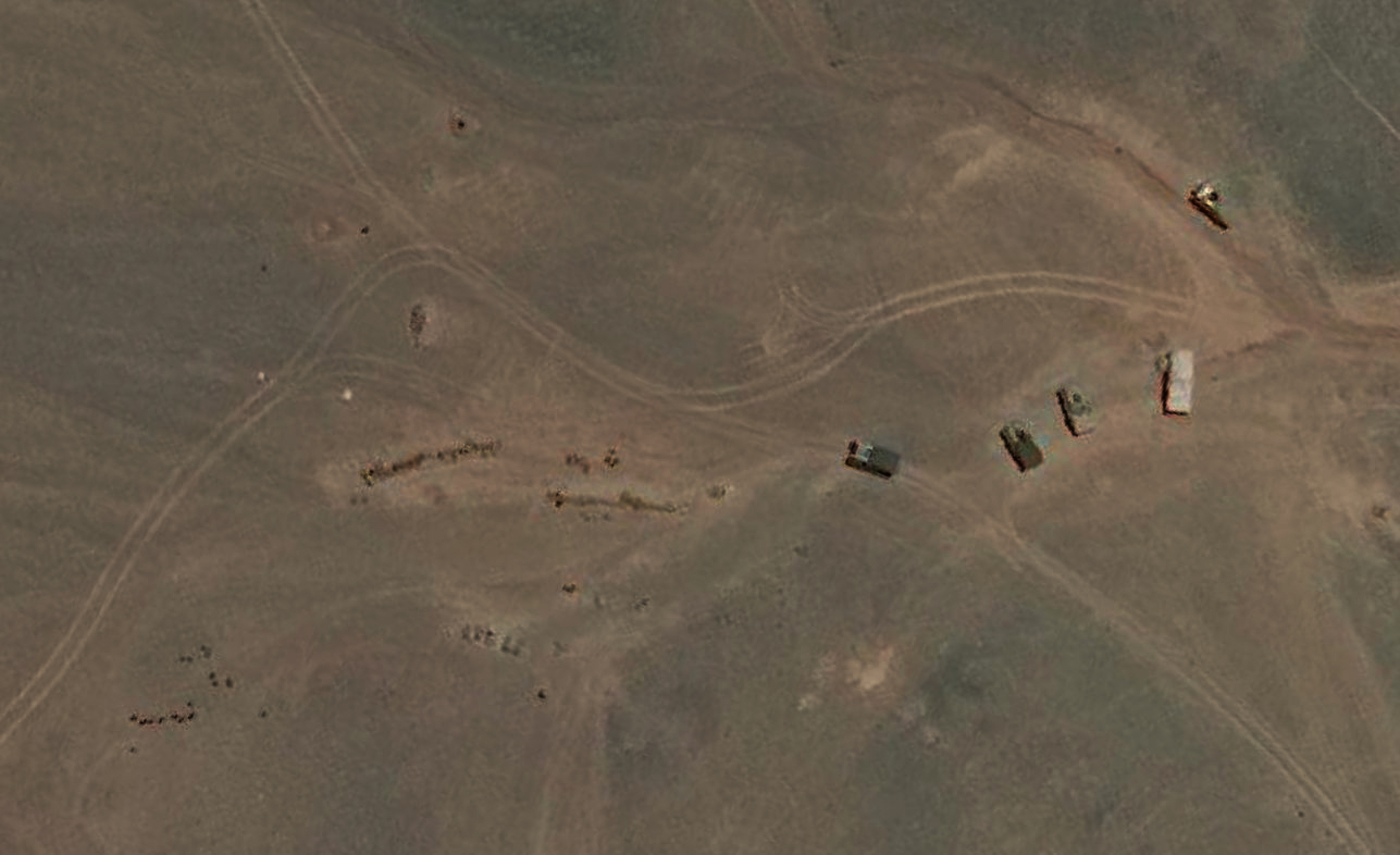
The PLA has marked its
presence at a crucial Y-junction near the Burtse patrol camp in Ladakh. Barely
30km south of the strategically important Daulat Beg Oldie ALG, this
Y-junction is also known as ‘bottleneck’ in Indian strategic circles because any
patrol seeking to reach either Point 10 or Point 13 along the Line of Patrol,
must cross this junction. It is interesting to recall that the PLA had crossed
the Y-junction and stopped barely 1,500 metres short of the Burtse camp in April
2013. Both India and China use the route along Raki Nala, north of Y-junction,
for patrolling purposes and it is not uncommon for both sides to run into each
other. In
1976, the Govt of India had constituted a China Study Group (an in-house
think-tank of the MEA), which revised the patrolling limits along the LAC. As
can be seen from the map, patrolling points 10, 11, 11A, 12 and 13 fall
slightly short of the LAC.
IA & PLA Martyrs


210 comments:
«Oldest ‹Older 201 – 210 of 210Sir, EAM n Modi m statements mei differences hai. U know them well. Mujhe to bs ye smjh aya that china claimed whole of Galvan valley to be theirs n they took it by force. N worst is Modi accepted it n declared it on national television. Gaya kisi ka kuch nahi q ki LAC decided nahi thi. Jo b reason ho kya fayda aisi fauj rkhne ka ispe itna paisa waste krne ka. Totally useless.
Sir, Capturing a strategic area of china is a possibilty for IA and then let them come to us for negotiation.
India has to take caliberted steps of escalation this time, keeping conflict localised at borders yet setting example.
Hello Prasun, I am amazed by the narrative being created that India is feeble, useless and utterly incapable of doing anything good to its country men, since India is always governed by people from Mars whose only purpose to self preservation and promotion. If anything positive happens then say that is by default and if anything negative, it proves the point that has always been said. Take any topic or issue that has been lingering for some many decades or centuries that has been resolved as examples and those that are still work in progress. Anyway, since this forum is rational, putting forth my views. All the best to strong souls who live through to gain digvijay rather than those shout out their weak emotions. One thing is for sure, the current setup has built a narrative of being patriotic and sensible to enhance the national interests. I do not see that thrown under the bus in a jiffy.
Thanks, Ganesh
Those who think galwan valley is gone just look at the LAC drawn by prasun sir for galwan valley picture:
https://1.bp.blogspot.com/-9IyPx6MtHRI/XsnMAZAVXXI/AAAAAAAATZE/4eBEiN6AVfk9NuUWjVfhN33gghcTkJ42ACLcBGAsYHQ/s1600/PLA-BDR%2BBuild-Up-1.png
Does PLA position across the indian side of LAC in Galway valley? No
Does PLA intrusion happened? Yes,in may 2020 but IA push them back to there side and that vedio was released.
So the status quo has not changed but build up happened on both sides of the LAC in Galway valley
@Ganesh,
"I am amazed by the narrative being created that India is feeble, useless and utterly incapable of doing anything good to its country men, since India is always governed by people from Mars whose only purpose to self preservation and promotion." Haaaa Haa haaa
Now coming to subject, after killing 20 brave Indian Soldiers the whole BJP is jumping to quit Chinese products. Just read this small article below
chinese crackers after Modi become Prime Minister
https://www.thehindu.com/news/national/tamil-nadu/chinese-crackers-a-stealthy-and-dangerous-import/article19744706.ece
All North Indian Bania Gang for their selfish, imported the Chinese Crackers and finished the famous Sivakasi Cracker Industry. BJP/Congress gang is part and parcel. Millions of daily wage workers lost the job and fall in poverty.
Suddenly people wake-up and shouting to Quit Chinese Products.
And GOOD NEWS, BCCI will continue to Use VIVO sponsorship for IPL where Amit Shah Son is the Secretary.
Churchil opposed Independence to India, reason he told this idiots don't know to rule. He is correct.
Thanks & Regards
Senthil Kumar
Can we transform the gains of the recent chinese intrusions in pangangtso lake to liabilities for china ? What options do we have in all fronts : Military , diplomatic, political and economical ? Can we introduce non-state actors to bleed them ?
But as you say and many experts say ,the need of the hour and everyone responsibility is to think what next with cool composed mind not by anger , vengence and nationalistic feeling.
Is there software based simulations that can suggest options to our leaders ?
As i understand right now the pressure to act and anger is more than sane thoughts . It is quite contraty on chinese side.
Dear Prasun,
Will the new proposed purchase of 21MiG29 be of UPG standard? Have the existing UPGs been cleared to carry Astra MK1?
In case of air skirmishes what is the advantage or disadvantage of IAF wrt PLAAF?
Is China merely playing this as a distraction for COVID19 pandemic and to divert world's attention?
Sir
This
https://m.tribuneindia.com/news/nation/sukhois-tanks-stacked-up-along-lac-101532
1) Where are we getting 2 new divisions from? We have just 1 extra division of MSC. Will we have to denude certain corps? I see Dehradun has 1 but it is dual tasked, facing China but part of Pakistan centric strike corps.
What units do we cover HP and UK with?
2) Any option to go in and sit tight at extreme end of Barahoti and settle their intrusions their forever?
3) Did we order 4 or 5 brahmos regiments?
https://economictimes.indiatimes.com/news/defence/army-to-have-2-more-regiments-of-brahmos-missile-manohar-parrikar/articleshow/51634075.cms
4) Can AASM be integrated with our mirages and excalibur with dhanush, sharang, k9 and Fh77 quickly?
We should request France and US to dip into their stocks and airlift them within this week on credit and a few more SPICE, only counter i see to the longer range MBRL and truck MGS available on either side to our enemies.
thanks once again for explanation.
Prasun Da, it seems that Nepal is quietly building logistics around the Kalapani area, after upgrading the Changru post near Kalapani, to a permanent one, now a Helipad. It appears to me PRC is indeed behind it, since as per media report the Chinese ambassador, was influencial on Oli's decision for up ante against India.
https://m.tribuneindia.com/news/nation/after-nepal-border-post-upgrade-comes-new-helipad-101530
https://youtu.be/o7XJwuFpxCM
https://youtu.be/eHQRbrgXyxA
And now, Nepal is parroting Chinese line, and blaming India occupying territories.
https://www.timesnownews.com/amp/videos/times-now/india/nepal-continues-to-parrot-chinas-script-claims-india-occupied-territory/63490
& Now,ratifying its citizenship law about Indians, meaning, IMHO targeting to wane India's options using Madhesi population. There's no law in India as such vis a vis Nepalese.
https://www.timesnownews.com/amp/india/article/nepal-amends-citizenship-law-for-indians-cites-indian-laws-to-justify-change/609491
This comes at a time at ever increasing anger in Nepalese people against Oli.
https://youtu.be/jlwEA7OzXhE
The door of diplomatic talks at present with Nepal is closed now, the Communist Government (getting highly unpopular) is now controlled by the PRC.
In the worst case scenario, Can China open confront India using Nepal's facilities in Changru?
Kindly share your views. Also request you to come up with a thread regarding present scenario including Nepal, and other neighbours,
possible Chinese gameplan and India's options.
Thanks in advance.
Hi Prasun,
I think your depiction of the Burtse camp on the google earth map is wrong.That point in your map is just 12 km from DBO. From what I found from open source info from net, Burtse camp is south of Depsang at 35°06'25"N 78°03'00"E.Its visible in Google Earth. The "Y" juntion seems to be at 35°08'55"N 78°07'00"E at a distance of 7.6 km from the Burtse camp.Distance from DBO to "Y" juntion - 31.5 km, which fits your description also.
In your 2nd map (orange background), just south of the Burtse camp there is a bend towards west, that's the DSDBO road taking the bend towards Murgo. The Jeevan nala seems to be south of Murgo around 6.6km south of Murgo.However in Google Earth, I couldnt demarcate the PPs.
Post a Comment